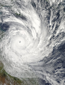
Severe tropical cyclone "Yasi" smashed across the north Queensland coast near Mission Beach, just to the south of Innisfail, around midnight on 2nd February. Producing wind gusts in excess of 200 kph, massive oceanic storm surges and torrential rain, it cut a trail of destruction through the area, with hundreds of houses destroyed or damaged, marinas smashed, massive dislocation of infrastructure and a devastation of Queensland's banana industry.
Above: Tropical cyclone "Yasi" approaches the Queensland coastline on 2nd February 2011. (Image courtesy of NASA, USA, click to enlarge)
Some 37 years before, on Christmas morning of 1974, tropical cyclone "Tracy" had stormed across Darwin, flattening a large area of the city and cutting off communications with the rest of the world for some six hours.
Both cyclones were probably of similar strength although "Yasi" was a far larger cyclone in area than the compact "Tracy".
 Satellite imagery of "Tracy", Christmas morning 1974. Comparison of this with the image above of "Yasi" shows the progress made in this area. Only two such images were received every day in 1974, and now they are available every hour. (Image courtesy of NOAA, USA)
But when comparing these two major disasters there is one vastly different outcome. 65 people lost their lives in "Tracy", and at the time of writing there are no known deaths attributed to "Yasi" although two people remain unaccounted for. But why is this so?
Firstly, weather prediction in general, and cyclone prediction in particular, has improved enormously since 1974. The availability of higher quality and more frequent satellite imagery, together with information from a larger number of automatic weather stations, has made a big difference.
 Devastation across Darwin produced by Tracy in December 1974. (Image from Wikipedia Commons - click to enlarge)
But one of the major factors is the progress in computer simulation of the atmosphere. The predicted tracks of tropical cyclones have become increasingly accurate, with useful warnings now issued up to a week ahead and this allows the population in affected areas to be well prepared.
An interesting example here concerns the week before "Yasi" when tropical cyclone "Anthony" formed off the north Queensland coast. The computer simulation predicted that it would then move southeast, before reversing direction and heading back towards the coastline. And this is precisely what happened, with the highly erratic path accurately predicted by Queensland meteorologists. This type of forecast was well outside the capabilities of meteorology in 1974.
And then there are the social factors - public education about tropical cyclones has raised awareness of the dangers of these systems and warnings are regarded far more seriously than in 1974. In the run up to "Tracy" warnings for tropical cyclone "Selma" were issued, but this system passed just by Darwin with little impact. For many this proved that weather forecasters "always got it wrong" and subsequent warnings for Tracy were largely ignored.
The role of NASA should be mentioned here - NASA is the acronym for the US based National Aeronautics and Space Administration, and NASA satellite imagery, such as that of "Yasi" above, is made freely available across the internet. This has been of immense value in raising interest and providing educational background to severe weather events such as cyclones and is therefore an enormous contribution. NASA's image web site can be found at
http://www.nasa.gov/multimedia/imagegallery/
The nature of the media has also changed. Television, in particular, will only run a story if "vision" is available and many severe weather events of the past were not covered for this reason. Now we have widespread availability of mobile phones that can take stills and movies good enough to use. This has revolutionised television coverage of severe weather events. Social media such as tweets, twitter and blogs have also produced major impact in raising community readiness.
Back in 1974, tropical cyclones were not big news in the southern states until they actually hit - now we have massive national media coverage well in advance, with The Weather Channel, I'm proud to say, playing a leading role.
 The Weather Channel's satellite display showing the remnants of "Yasi" moving across northern Queensland.
(Click to enlarge)
http://www.weatherchannel.com.au/
The integration of meteorology with State emergency services has advanced considerably. This ensures that people are warned early, evacuated from areas of danger, and also allows the recovery to be managed more efficiently.
The use of the Press Conference, involving in this case the Premier of Queensland Anna Bligh, before the cyclone struck, and then during the aftermath, was also of immense value, and more than likely has saved lives and reduced property damage.
The considerable sum invested by Australia in the area of tropical cyclone warning and prediction has been more than worth it, and will continue to produce positive outcomes in disastrous situations.
In early 1975 the Australian duo "Bill and Boyd" composed the following song as a fundraiser for the victims of "Tracy" - it's a rare example of a song composed in response to a weather disaster.
http://www.youtube.com/watch?v=VJi_kBIiZ4A&feature=related
For some thoughts on how weather prediction has evolved over the centuries go to
http://passingparade-2009.blogspot.com.au/2011/07/brief-history-of-weather-forecasting.html
No comments:
Post a Comment